Всё
 |
|

Comments
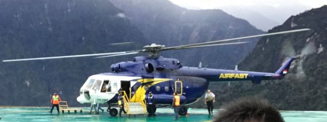
I would say that this must be up at a very high Elev location. This is close to the Equator and it looks like the Mil is parked on an ice pad.
I just did some checking...this icy looking pad must be situated less than 5 degrees South of the Equator.
I just did some checking...this icy looking pad must be situated less than 5 degrees South of the Equator.
Chris. Looks like Grasberg Mine, Pt Freeport Gold & Copper, Indonesia. The elevation is some 3,730 meters (12,240 feet). The helipad is painted green, so I don't think it is ice. Maybe damp.
https://www.facebook.com/pages/HelipadFreeport-Site-PAPUA/427313290679085?rf=519734034742927
https://www.facebook.com/pages/HelipadFreeport-Site-PAPUA/427313290679085?rf=519734034742927
https://www.google.com/maps/place/PT.+Freeport+Indonesia/@-4.088452,137.1027516,23421m/data=!3m1!1e3!4m5!3m4!1s0x682377469f96e671:0x2c10d745361abb57!8m2!3d-4.0665869!4d137.1199322
Thanks Viv. Yep, at that height the OAT would probably be around 8 C, so probably not ice. I know that the mountain peak up there above the mine is close to 17,000 feet. During WW2 the height of that mountain range was underestimated on their best available charts, which accounted for the loss of at least one Allied transport flying in cloud.
No worries, Chris. And thanks for the info re the Allied loss in WW2 - interesting info.
|
ЖУРНАЛ АКТИВНОСТИ
Хотите просмотреть все архивные записи о PK-OMS (с 1998 г.)? Купите сейчас, получите через час.
|
| Дата | Воздушное судно | Аэропорт вылета | Аэропорт прилета | Вылет | Прилет | Длительность |
|---|---|---|---|---|---|---|
| 20 апр 2024 | Unknown | Timika (TIM / WAYY) | Timika (TIM / WAYY) | 07:55 WIT | 08:01 WIT (?) | 0:05 |
| 20 апр 2024 | Unknown | Timika (TIM / WAYY) | Timika (TIM / WAYY) | 06:59 WIT | 07:00 WIT | 0:01 |
| Зарегистрированные пользователи (регистрация бесплатна и не вызовет сложностей!) могут просматривать архив за 3 months. Регистрация | ||||||
Please log in or register to post a comment.